
Yeah as NC has stated, you can have the deepest of lows but without a strong supporting high pressure system compressing pressure gradients on one or more of the lows flanks, you won't get anywhere near as much swell.
Also just in case you didn't know Low's spin Clockwise in the Southern Hemisphere and High's anti-clockwise.
And as Sean stated to you Nick, winds around High pressure systems are much stronger than around an equivalent Low, but I can't quite remember back to my physical and dynamical Met studies, why??
May come back with an answer later.. (May be the added influence of gravity on the descending air at the centre of a high, pushing out across the surface but i'll get back to you).
October
Moderators: collnarra, PeepeelaPew, Butts, Shari, Forum Moderators
Re: October
so being more dense, a High moves fast?
a very different slant to dazzas scant imaginings, yay
a very different slant to dazzas scant imaginings, yay
-
Donweather
- Harry the Hat
- Posts: 2599
- Joined: Tue Feb 19, 2008 9:29 pm
Re: October
I'm really struggling with this one Craig?SAsurfa wrote:And as Sean stated to you Nick, winds around High pressure systems are much stronger than around an equivalent Low, but I can't quite remember back to my physical and dynamical Met studies, why??
How can a high pressure system have an "equivalent" low pressure system? What is equivalent (ie equal) between the high and low? I'm not getting how they can be equal?
I think Nick was more alluding to the fact that highs can be way more stationary and have a much longer fetch than a low pressure system, thus generating much larger swell for the same wind speeds?
Re: October
Physics. Hi is colder and heavier.
Re: October
Ok, you might have to sit down and think about this one a bit..
Below is a quick diagram I drew up in word..
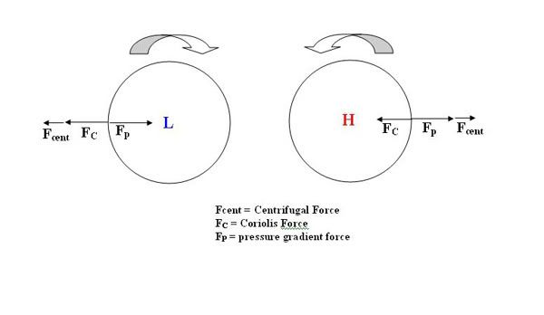
It shows both a High and Low pressure system from the Southern Hemisphere and the bubble arrow above each circle points out that high's spin anti-clockwise, and low's clockwise. Good so far??
Now also shown is the balance between the pressure gradient force, centrifugal force and coriolis force.
So in the low we have a pressure gradient force heading towards the centre (pressure tries to equalise by going from high to low), and the Coriolis force deflecting flow to the left (in the southern hemisphere), and also the centrifugal force which is out and away from the low (much like holding a strong with a ball attached and swinging it around).
Now in the high we have the same Coriolis force deflecting to the left and the centrifugal force out from the centre of the high, but the pressure gradient force is now also outwards due to pressure going from high to flow.
Now the gradient wind is the balance of these 3 forces for both the low and high, and this is the wind we get along isobars (although there is a slight deviation in real life due to friction but ignore that for this explanation).
Geostrophic wind is just simply the balance of the Pressure gradient force and Coriolis (no curvature)
Now if the pressure gradient force is kept constant we can see with the Low that the coriolis force will change to keep the balance equal on either side of the equation, so it will decrease resulting in a decrease in wind speeds.
Now with the high, also if the gradient force is kept constant we can see with that the coriolis force will increase to keep the balance equal on either side of the equation, resulting in an increase in wind speeds (Hence high's having greater Gradient wind speeds around them than an equivalent low)
Here is a link that may help as well, the last 3 pages are what concerns us..
http://www.eas.slu.edu/People/CEGraves/ ... Emily2.pdf
What this has to do with anything we're concerned about though baffles me


Below is a quick diagram I drew up in word..
It shows both a High and Low pressure system from the Southern Hemisphere and the bubble arrow above each circle points out that high's spin anti-clockwise, and low's clockwise. Good so far??
Now also shown is the balance between the pressure gradient force, centrifugal force and coriolis force.
So in the low we have a pressure gradient force heading towards the centre (pressure tries to equalise by going from high to low), and the Coriolis force deflecting flow to the left (in the southern hemisphere), and also the centrifugal force which is out and away from the low (much like holding a strong with a ball attached and swinging it around).
Now in the high we have the same Coriolis force deflecting to the left and the centrifugal force out from the centre of the high, but the pressure gradient force is now also outwards due to pressure going from high to flow.
Now the gradient wind is the balance of these 3 forces for both the low and high, and this is the wind we get along isobars (although there is a slight deviation in real life due to friction but ignore that for this explanation).
Geostrophic wind is just simply the balance of the Pressure gradient force and Coriolis (no curvature)
Now if the pressure gradient force is kept constant we can see with the Low that the coriolis force will change to keep the balance equal on either side of the equation, so it will decrease resulting in a decrease in wind speeds.
Now with the high, also if the gradient force is kept constant we can see with that the coriolis force will increase to keep the balance equal on either side of the equation, resulting in an increase in wind speeds (Hence high's having greater Gradient wind speeds around them than an equivalent low)
Here is a link that may help as well, the last 3 pages are what concerns us..
http://www.eas.slu.edu/People/CEGraves/ ... Emily2.pdf
What this has to do with anything we're concerned about though baffles me
Last edited by SAsurfa on Wed Oct 14, 2009 11:46 pm, edited 4 times in total.
Re: October
^ matches Nick and Sean's strong high causing a scarey :? wind band :? 
What's a :? deep low :? , is it a low with enough force to balance a :? broad high :? like in both your equation and diagram?Nick Carroll wrote:hjey dazzadaryl wrote:Today this looks good, with a Low from NZ to here. Or is it? Just barely, there's a Low over Aus, which is/was another one of my original questions, What can you expect when the Low is over Aus, as compared to one that's over NZ
it's not about the Low, it's about the wind.
Lows are only part of the picture. Like...one of easteern Oz's best swell sources is the wind band that forms north of a big temperate high centred near NZ. (Eh donweather.)
I remember Sean Collins telling me once (he used to spend hours explaining all this shit to me) that yeah, a strong low was all awesome etc, but the scariest wind band was one that formed along the edge of a powerful high pressure system. To quote him, "it's like a brick wall".
The best swells are those formed when a strong, broad high pressure system jams up against a deep low and the wind blows like fcuk over a lot of very deep water.
Re: October
Daryl, its all relative. It's like asking what's a cold temperature to someone in the tropics and someone up in Alaska
But just to help out my explanation above..
Here's the digram again.
Now the Gradient wind again is the balance of the pressure gradient force, Coriolis force and centrifugual force.
i.e. for the low COR + CENT = PGF and this creates a winds that travels in a clockwise direction.
So to understand the point i'm making, imagine the wind tries to keep heading in a straight line, and not in a clockwise direction As the PGF is constant, the only thing that can change is the Coriolis force, and as this is acting in out and away from the low, it has to decrease to lesten the force acting outwards and allow the wind to curve in a clockwise direction. So a decrease in COR leads to an overall decrease in the Gradient Wind 
No with the high the balance is COR = PGF +CENT and this creates wind that travels anti-clockwise.
So again imagine the wind want to continue to travel in a straight line. As the PGF is constant the only way to pull back the wind towards the high and in an anti-clockwise direction is to increase the Coriolis force. This will allow the wind to curve in an anti-clockwise direction. So an increase in COR leads to an overall increase in the Gradient Wind.
So this proves that Gradient wind is stronger around a high than a low.
If you need an extra diagram I will draw one???
But just to help out my explanation above..
Here's the digram again.
Now the Gradient wind again is the balance of the pressure gradient force, Coriolis force and centrifugual force.
i.e. for the low COR + CENT = PGF and this creates a winds that travels in a clockwise direction.
So to understand the point i'm making, imagine the wind tries to keep heading in a straight line, and not in a clockwise direction
No with the high the balance is COR = PGF +CENT and this creates wind that travels anti-clockwise.
So again imagine the wind want to continue to travel in a straight line. As the PGF is constant the only way to pull back the wind towards the high and in an anti-clockwise direction is to increase the Coriolis force. This will allow the wind to curve in an anti-clockwise direction. So an increase in COR leads to an overall increase in the Gradient Wind.
So this proves that Gradient wind is stronger around a high than a low.
If you need an extra diagram I will draw one???
Re: October
SAsurfa: "the balance is COR = PGF +CENT and this creates wind that travels anti-clockwise"

Re: October
What would cause the Coriolis to increase "to keep balance", if it got cold or something?SAsurfa wrote:Daryl, its all relative. It's like asking what's a cold temperature to someone in the tropics and someone up in Alaska
But just to help out my explanation above..
Here's the digram again.
Now the Gradient wind again is the balance of the pressure gradient force, Coriolis force and centrifugual force.
i.e. for the low COR + CENT = PGF and this creates a winds that travels in a clockwise direction.
So to understand the point i'm making, imagine the wind tries to keep heading in a straight line, and not in a clockwise direction
No with the high the balance is COR = PGF +CENT and this creates wind that travels anti-clockwise.
So again imagine the wind want to continue to travel in a straight line. As the PGF is constant the only way to pull back the wind towards the high and in an anti-clockwise direction is to increase the Coriolis force. This will allow the wind to curve in an anti-clockwise direction. So an increase in COR leads to an overall increase in the Gradient Wind.
So this proves that Gradient wind is stronger around a high than a low.
If you need an extra diagram I will draw one???
Ooh, yes, please
Yeah so well he prob'ly designed your mobi2nd Reef wrote:SAsurfa: "the balance is COR = PGF +CENT and this creates wind that travels anti-clockwise"
-
Donweather
- Harry the Hat
- Posts: 2599
- Joined: Tue Feb 19, 2008 9:29 pm
Re: October
Thanks Craig. I understand what you're alluding too now and it makes sense.
Can you just now draw one of those high's out near NZ and leave it there for a week or two please!!!
Can you just now draw one of those high's out near NZ and leave it there for a week or two please!!!
-
steve shearer

- BUTTONMEISTER
- Posts: 45647
- Joined: Mon Oct 13, 2008 8:20 pm
Re: October
Donweather wrote: I think Nick was more alluding to the fact that highs can be way more stationary and have a much longer fetch than a low pressure system, thus generating much larger swell for the same wind speeds?
The great sub-tropical secret.
BTW....great diagrams Craig.
I want Nightclub Dwight dead in his grave I want the nice-nice up in blazes
-
el rancho

- Duke Status
- Posts: 12544
- Joined: Wed Aug 19, 2009 11:22 am
- Location: taking a shit in the dunes
Re: October
so where are the winds strongest in the high pressure system? edges or centre?
this is fascinating and good to learn. thanks guys!
this is fascinating and good to learn. thanks guys!
Re: October
At the edges El Rancho, the centre of high pressure systems see light winds and clear skies due to the sinking denser air.
-
el rancho
- Duke Status
- Posts: 12544
- Joined: Wed Aug 19, 2009 11:22 am
- Location: taking a shit in the dunes
Re: October
yeah thats what I thought I knew, calm and clear. relatively.
phew, not a total noob.
cheers.
phew, not a total noob.
cheers.
-
Nick Carroll
- Huey's Right Hand
- Posts: 26515
- Joined: Tue Apr 05, 2005 9:29 am
- Location: Newport Beach
Re: October
Equidistant from the surface atmospheric mean (around 1015mb)Donweather wrote:How can a high pressure system have an "equivalent" low pressure system? What is equivalent (ie equal) between the high and low? I'm not getting how they can be equal?
thanks for the hi tech there sasurfa, awesome!
you can almost picture it ... that vast mountain of air, spilling its excess out and down the slope toward the surface, being wrenched into a turbine by the spinning Earth.
Unimaginable forces at play and we get a free ride on its coattails.
Re: October
or, should I be saying
maybe , the barometer's still over 1009
Latest Coastal Weather Observations for New South Wales
- WTF does ^ this ^ tell me :-(
- Attachments
-
- the high and low should add up to a southerly :-|
-
- voila, snap, there it is, a fricken southerly :-)
- aus24-2.gif (78.1 KiB) Viewed 4276 times
Re: October
Interesting stuff aye Daz.Iv'e been reading about this siht for years and I'm still struggling to get my head around it.I just think:high=anti-clockwise,low=clockwise.The closer the lines are the stronger the wind is and if the lines are pushing towards me then so is the swell....... So we should see a small sth swell tomorrow maybe ...
Re: October
in the middle of a high, and halfway between everywhere else but here.
Who is online
Users browsing this forum: No registered users and 4 guests