LONGINUS wrote:Steve / Don - can you run some models and see if I am going to get any of this NE energy in Northern Indo around the Molukas in about a week? Been there 3 times and failed in the past. With this much energy bouncing around the Pacific I don't see how I can loose this time.
Anything extending down towards the Phillippines?
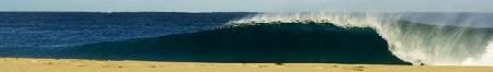
Longi, I've been running some numbers from this swell event for the destination of my Surfari early next year, which is considerably further east of your locations above, and unfortunately the fetch of this storm was both located in the central-NE corner of the North Pacific and predominantly aimed W/NW, thus any locations in the Tropical South Pacific and further west again into PNG and north Indo are really only seeing a limited radial spread fraction of the swell. Periods are damn good, but swell heights only look to be about 4ft@16 seconds, probably equating to something in the order of 5ft, perhaps 6ft at some deeper water outer north facing reef locations this coming weekend.
So your location/s further west would be seeing some further dilution both in terms of swell heights and swell periods.
Those locations really require something to blow up just off Japan (probably a little later in the swell season....like late Dec/Jan) for it to really see some solid swell from the North Pacific winter.
Some boys from Quiksilver and Volcom are currently at my surfari destination (for next year) shooting and filming some footage, so let's hope the local winds behave (pending developments of said tropical low) for the peak of the swell this coming Sat/Sun up there and thus we'll get to see some good pics/DVD etc.