Can't find the right forum, then post your general surf-related remarks here!
Moderators: jimmy, collnarra, PeepeelaPew, Butts, beach_defender, Shari, Forum Moderators
-
SAsurfa
- barnacle
- Posts: 1387
- Joined: Sat Apr 29, 2006 1:18 am
- Location: 20 hours drive away..
Post
by SAsurfa » Tue Jun 03, 2008 8:25 pm
mustkillmulloway wrote:
tiger whinging about the charts saying the run in should started a hour ago in my tinnie in noosa river

as the tide pushed out for the next 4
he was cursing...but than again he'd just made a great

cast into a tree
Well I can't help tiger's errant tidal readings and rod casting skills

december

standing in foot deep water retrivng a trap @ a time the charts had offically said was a 1.3 mtr high

Just because the tide says it 1.3m doesn't mean its going to be 1.3m everywhere you step into the ocean. It's at the point that's indicated on the tidal chart
THEY COULD BE OK IF GIVEN FOR A MONTH...BUT REALLY...the people at bom or flinders...have no idea...less time figuring more time experncing would help

They can be preditced into the future for as long as you want as they are calculated on the cycles on the moon and sun which are well known. It's just like plugging in numbers into a big formula, you can't go wrong

-
tiger
- barnacle
- Posts: 1148
- Joined: Wed Jan 21, 2004 8:52 am
- Location: very fickle!
Post
by tiger » Tue Jun 03, 2008 8:29 pm
mustkillmulloway wrote:SAsurfa wrote:mustkillmulloway wrote:
[stupid bull.shi.t fictional flinders uni s.a guide too bull.s.hit tides thats never right bull.sh.it uni students don't know shit couldn't frockin do anything right
When and where have you run into trouble with tidal predictions

shall i start with the latest
tiger whinging about the charts saying the run in should started a hour ago in my tinnie in noosa river
as the tide pushed out for the next 4
he was cursing...but than again he'd just made a great
cast into a tree
december
standing in foot deep water retrivng a trap @ a time the charts had offically said was a 1.3 mtr high
mate...tide charts are CRAP....THEY FAIL TOO PREDICT THE TIDES OVER A YEAR
THEY COULD BE OK IF GIVEN FOR A MONTH...BUT REALLY...the people at bom or flinders...have no idea...less time figuring more time experncing would help
But didn't that tree put up a good fight! That's why I mostly fish in the fresh Fong. One less part of the puzzle to have to contend with. It's not the forecasters that don't know what the tides doin', it's the stupid rivers themselves! As long as they're accurate with what the tides doin' at the beaches and points, I'm a happy camper.

-
thermalben
- charger
- Posts: 963
- Joined: Sun Jan 11, 2004 7:35 pm
- Location: Tweed Coast
Post
by thermalben » Tue Jun 03, 2008 8:42 pm
mustkillmulloway wrote:mate...tide charts are CRAP....THEY FAIL TOO PREDICT THE TIDES OVER A YEAR
Tide charts are a prediction based on lunar/solar, and geographical/bathymentrical influences. However, there are several other factors that influence the actual height of the water levels - strong onshore winds can "pile up" water in the coastal zone, whilst strong offshore winds can have the opposite effect.
Probably the most common factor is the inverse barometer effect, whereby the sea level surface is affected by the pressure of the atmosphere. For every 1hPa increase in sea level pressure, there is a corresponding drop in sea surface height by 1cm. We typically use 1013hPa as the "mean" surface pressure across the globe, so let's imagine a low pressure system with a central pressure of 983hPa crossing the coast. This low is 30hPa lower than the mean SLP, so the water level will rise by an additional 30cm (on top of the predicted height of the tide) in the vicinity of the low.
Other factors that can lead to higher-than-forecast tides include coastal trapped waves and large amounts of rainfall runoff - this last one usually has only a small influence, but coupled in with a spring tide, sustained onshore winds, a deep low pressure system crossing the coast and a coastal trapped wave, can certainly add a little more water to already swollen shores.
-
Buff_Brad
- barnacle
- Posts: 2299
- Joined: Sat Nov 17, 2007 4:43 pm
- Location: Wall Street
Post
by Buff_Brad » Tue Jun 03, 2008 9:11 pm
thermalben wrote:Buff_Brad wrote:The variances, or squared standard errors, of estimates of tidal harmonic constants from analyses of a month or a year of tide-gauge data are analysed in terms of spectral properties of their noise continuum, modelled as exponential cuspsE 1 superimposed on a smoothly monotonic non-tidal spectrumE 0. Taking 5 representative stations, each with 19 years of data,E 0 is evaluated from the inter-species noise levels, andE 1 from the ratio of the variances from monthly and yearly analyses. It is shown that the cusps surrounding the diurnal tides are dominated byE 0, whereas the more important semi-diurnal and higher species cusps are fitted by an exponential form forE 1 with bandwidth of a few cycles per year. The variance ratios (monthly: yearly analyses) for diurnal harmonics are somewhat greater than the value expected for white noise, partly because of residual tidal lines in the monthly analyses which cannot be related to the major constituents. The corresponding ratios for semi-diurnal and higher species harmonics are less than the white noise value, on account of the cusps. The standard errors of yearly estimates of the larger tidal constituents may be predicted as proportional to their mean amplitude, as a very rough guide, in the approximate ratio of 11 mm/m.
Simply put.......there's a "noise" factor fellas. Like the noise factor in listening to radio waves.
C'mon Brad, if you're gonna
rip stuff straight off the web - at least quote your source! (apologies in advance if you're either David E. Cartwright or Muhammad Amin, and worked at the Institute of Oceanographic Sciences, Bidston in 1986).
Apologies to Mr Cartwright or Muhammad Amin.....just finding that article let alone reading it gave me a headache. Fuc.k knows why the tides are different in different estuaries even next to one-another??? Isn't something to do with the "bulging" effects of the oceans that is incredibly difficult to measure especially on a minute scale? I'm certainly no oceanographer although I vaguely considered doing it at uni at one time. Ha ha knew someone would google it.
-
oldman
- Snowy McAllister
- Posts: 6886
- Joined: Tue Feb 10, 2004 1:11 pm
- Location: Probably Maroubra, goddammit!
Post
by oldman » Wed Jun 04, 2008 12:15 pm
TrevG wrote:Mackay's height tonight is 6.26 m

and on the point of the "different" stick, their preceeding low is 0.36 m.
Which means a tidal rise of 5.9 meters
Imagine that at The Bower or Maroubra or The Island.
Is that fair dinkum TrevG?
Does Mackay really get the tides first in Australia? Maybe they have some claim to it, I just don't really understand it.
Or is that reading taken somewhere down river and not reflecting open ocean tidal range.
-
oldman
- Snowy McAllister
- Posts: 6886
- Joined: Tue Feb 10, 2004 1:11 pm
- Location: Probably Maroubra, goddammit!
Post
by oldman » Wed Jun 04, 2008 12:20 pm
SAsurfa wrote:They can be preditced into the future for as long as you want as they are calculated on the cycles on the moon and sun which are well known. It's just like plugging in numbers into a big formula, you can't go wrong
Yeah they can be predicted, but they are predictions only SASurfa. It seems there is too much noise in the system as their predictions are a lot hazier than people think. i.e. you can go wrong.
Further, I don't agree with your comments re the bathymetry at least in respect to the east coast. That would and does apply to places like the spencer gulf and gulf of carpentaria where huge amounts of water are bumped up against a land mass, and thus changes the tidal flow significantly, however I don't think that applies to the east coast of oz, which is largely completely exposed to the full tidal range.
-
Trev
- Huey's Right Hand
- Posts: 31078
- Joined: Mon Feb 23, 2004 3:11 pm
- Location: Any Point Break
Post
by Trev » Wed Jun 04, 2008 12:39 pm
oldman wrote:TrevG wrote:Mackay's height tonight is 6.26 m
and on the point of the "different" stick, their preceeding low is 0.36 m.
Which means a tidal rise of 5.9 meters
Imagine that at The Bower or Maroubra or The Island.
Is that fair dinkum TrevG?
Does Mackay really get the tides first in Australia? Maybe they have some claim to it, I just don't really understand it.
Or is that reading taken somewhere down river and not reflecting open ocean tidal range.
It says "Mackay-Outer Harbour"
Follow this link and you can compare anywhere in Qld (and I guess you can back up in the BOM website and get other states)
http://www.bom.gov.au/oceanography/tides/MAPS/qld.shtml
Don't know about the "first" tides in Australia - that was in someone else's post, but I guess you could work that out from the times on the above charts.
-
doowdle
- newbie
- Posts: 29
- Joined: Thu Sep 20, 2007 3:13 pm
Post
by doowdle » Wed Jun 04, 2008 12:45 pm
The tides vary in different locations due to the corriolis force, not just gepgraphy.
Corriolis makes the tides swirl around central points, if you are on one of those points, no tide, if you are away from one of those points, big tide.
Interestingly, stone henge is on one of those points, did the cave men know?
-
oldman
- Snowy McAllister
- Posts: 6886
- Joined: Tue Feb 10, 2004 1:11 pm
- Location: Probably Maroubra, goddammit!
Post
by oldman » Wed Jun 04, 2008 12:56 pm
TrevG wrote:[It says "Mackay-Outer Harbour"
Follow this link and you can compare anywhere in Qld (and I guess you can back up in the BOM website and get other states)
http://www.bom.gov.au/oceanography/tides/MAPS/qld.shtml
Don't know about the "first" tides in Australia - that was in someone else's post, but I guess you could work that out from the times on the above charts.
Thanks Trev
Some very useful info there. I'm going through it as I get the chance. Willhave to re-visit that book I have on lunar orbits, which if I recall correctly have a number of cycles, one of which is over a 19 year period.
-
countrybumkin
- Grommet
- Posts: 81
- Joined: Mon Feb 16, 2004 1:01 pm
Post
by countrybumkin » Wed Jun 04, 2008 3:06 pm
mustkillmulloway wrote:
some will get wet....some people will scream terror
others will return home with big jewies and plough Tammy's back paddock
-
SAsurfa
- barnacle
- Posts: 1387
- Joined: Sat Apr 29, 2006 1:18 am
- Location: 20 hours drive away..
Post
by SAsurfa » Wed Jun 04, 2008 3:19 pm
doowdle wrote:
Interestingly, stone henge is on one of those points, did the cave men know?
How though, it's on land?
Or is there a tidal node in the sea near the stonehenge?
And oldman, the tidal range changes everywhere because there are nodes where little tidal movement is seen and points where a maximum tidal range is seen.
Here is a diagram showing the tidal range for the world..
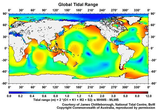
You can see that the range changes all over the world and even along the East coast of Australia if you look hard enough
I was trying to get a diagram of the tidal ranges for just the East coast of Oz so you could see the changes more easily, but couldn't find one in my quick search.
And the predictions are very close to the observed except for the influences that thermalben mentioned.
EDIT: Sorry I thought it might not work because you have to be registered user to see it, but it worked in my preview :? Anyway I uploaded it to photobucket now and re-linked it

Last edited by
SAsurfa on Wed Jun 04, 2008 3:28 pm, edited 1 time in total.
-
wanto
- barnacle
- Posts: 2413
- Joined: Sun May 06, 2007 9:25 am
Post
by wanto » Wed Jun 04, 2008 3:24 pm
your image no work, post link. thx!
-
doowdle
- newbie
- Posts: 29
- Joined: Thu Sep 20, 2007 3:13 pm
Post
by doowdle » Wed Jun 04, 2008 3:46 pm
SAsurfa wrote:doowdle wrote:
Interestingly, stone henge is on one of those points, did the cave men know?
How though, it's on land?
ok, your pushing my limeted brain power, but i guess its a sort of observed center of the effect, a theoretical point, rather than something thats acting on the system (the body of water).
these nodal points have a special name when they are on land, and its something like deliquent, or retarded or something. can't remember what and my google powers have failed me, anyone else know? the points in general are called amphidomes.
-
SAsurfa
- barnacle
- Posts: 1387
- Joined: Sat Apr 29, 2006 1:18 am
- Location: 20 hours drive away..
Post
by SAsurfa » Wed Jun 04, 2008 3:50 pm
doowdle wrote:
ok, your pushing my limeted brain power, but i guess its a sort of observed center of the effect, a theoretical point, rather than something thats acting on the system (the body of water).
Interesting, I have never heard of these. I would also like some more information on these points..
-
thermalben
- charger
- Posts: 963
- Joined: Sun Jan 11, 2004 7:35 pm
- Location: Tweed Coast
Post
by thermalben » Wed Jun 04, 2008 3:56 pm
Qld's EPA post near-real time tide data, including actuals, predictions and residuals. So, you can see how "accurate" the tide forecast really is.

-
SAsurfa
- barnacle
- Posts: 1387
- Joined: Sat Apr 29, 2006 1:18 am
- Location: 20 hours drive away..
Post
by SAsurfa » Wed Jun 04, 2008 4:09 pm
Check Mate Fong
-
vb
- Local
- Posts: 653
- Joined: Fri Jan 16, 2004 8:57 pm
- Location: above the bends
Post
by vb » Wed Jun 04, 2008 5:14 pm
Never been to Indo; seems (going on the global chart) it's massively affected by the tides. Is that so?
-
mustkillmulloway
- Owl status
- Posts: 4893
- Joined: Sat Nov 11, 2006 9:15 pm
- Location: i live in a pineapple under the sea
Post
by mustkillmulloway » Wed Jun 04, 2008 5:39 pm
SAsurfa wrote:Check Mate Fong

well...there still shit

why do i have add a hour for daylight saving...yeah...why
can't the stupid uni students figure that into the charts for me
( they can predict the tides a year in advance but daylight savings beyond them
)
and why aren't produced on water proof paper...yeah
and .. yeah...thats it...thanks for shooting my argument in foot therben
p.s i'd still trust a look out the window over a chart anyways

Who is online
Users browsing this forum: No registered users and 206 guests