What surfer doesn't care about the weather? Who hasn't predicted the arrival of a new swell? Do all of it here!
Moderators: collnarra, PeepeelaPew, Butts, Shari, Forum Moderators
-
diggerdickson
- barnacle
- Posts: 2319
- Joined: Sat Jan 10, 2009 11:26 am
- Location: home is where the heart is.
Post
by diggerdickson » Fri Jan 14, 2011 12:22 pm
Donweather wrote:diggerdickson wrote:Hey don, people are talking about a cyclone coming just after australia day, any information on this mate, I havent had a chance to check it out and was wondering if you had heard anything about this.
That weatherman is a fecking idiot. He posted a GFS map that was +368hrs away!!! I couldn't stop laughing at the ridiculous maps he was putting up and he then quoted a 30-40% chance of that chart coming off. What a tool. The chances of the chart that the dickhead weather man put up coming off would not be 30-40%. In fact it wouldn't even be 3-4%. In fact if those charts were progging a cyclone that far out, I'd put money on it that there wasn't going to be one off SE Qld on 28 Jan....and I'd be putting a lot of money on it!!! Media hype yet again and scare mongering.[/quote
mmm, that bloke should read the book how to destroy your credibilty in your work place in one easy step

no, Im not a surfer, Im just a garbage man".
-
SAsurfa
- barnacle
- Posts: 1387
- Joined: Sat Apr 29, 2006 1:18 am
- Location: 20 hours drive away..
Post
by SAsurfa » Fri Jan 14, 2011 7:16 pm
Here's the chart...
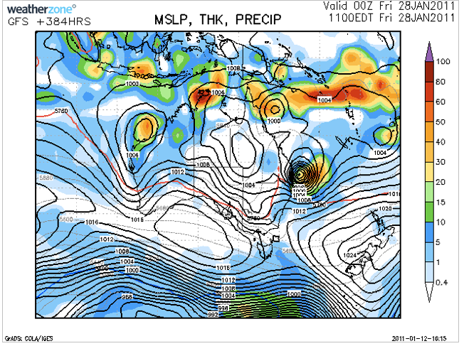
Idiot!
-
Donweather
- Harry the Hat
- Posts: 2599
- Joined: Tue Feb 19, 2008 9:29 pm
Post
by Donweather » Sun Jan 16, 2011 4:10 pm
Bugger me there's some serious swell in the water now, and not too far off my hand calcs earlier in the week either.
3.5m @ 14sec+ with Hmax above 6m!!!!
Can someone please tell me why there's such a huge difference between the GC wave buoys and the Mooloolaba wave buoy? This swell was created some reasonable distance offshore and hence radial spreading should mean there's bugger all difference between the wave buoy readings along SE Qld?
-
Quangers
- Local
- Posts: 589
- Joined: Fri Mar 07, 2008 8:55 pm
- Location: down a secluded bush track
Post
by Quangers » Sun Jan 16, 2011 9:15 pm
Lucky buggers. There was nought down south nsw this morning (2-3 ft, shouldn't whinge it is summer).
Have to work the next few days too.

-
oldman
- Snowy McAllister
- Posts: 6886
- Joined: Tue Feb 10, 2004 1:11 pm
- Location: Probably Maroubra, goddammit!
Post
by oldman » Sun Jan 16, 2011 9:54 pm
Interesting.
Today's pics on the realsurf website show a few shots which they call 3 -4 foot, which I think look more like 2-3 foot on the iggy scale.
Easily twice that on the central coast today. 3 to 4 (Iggy) from fairly early and built through most of the day. Some a fair bit bigger than that.
Considering that north narrabeen is supposed to be a swell magnet, looks like they didn't get as much of the swell as I saw up here. Would be interested to hear what other people were seeing on Sydney beaches today.
Lucky Al wrote:You could call your elbows borogoves, and your knees bandersnatches, and go whiffling through the tulgey woods north of narrabeen, burbling as you came.
-
oldman
- Snowy McAllister
- Posts: 6886
- Joined: Tue Feb 10, 2004 1:11 pm
- Location: Probably Maroubra, goddammit!
Post
by oldman » Mon Jan 17, 2011 9:14 am
Today's pics of north narra a bit more like what we are getting up here.
Whereas yesterday had regular sets and good size, today has just maxed out and nowhere in my vicinity is surfable from what I can tell. Out of control.
Maybe will calm down a bit as the afternoon wears on and the tides change.
Lucky Al wrote:You could call your elbows borogoves, and your knees bandersnatches, and go whiffling through the tulgey woods north of narrabeen, burbling as you came.
-
SAsurfa
- barnacle
- Posts: 1387
- Joined: Sat Apr 29, 2006 1:18 am
- Location: 20 hours drive away..
Post
by SAsurfa » Mon Jan 17, 2011 9:53 am
What size would you put on it?
-
oldman
- Snowy McAllister
- Posts: 6886
- Joined: Tue Feb 10, 2004 1:11 pm
- Location: Probably Maroubra, goddammit!
Post
by oldman » Mon Jan 17, 2011 8:52 pm
First thing I saw this morning. 10 wave set, most of them double overhead plus.
Top of the tide - disorganised mess, rips everywhere and hard to gauge - just a mess.
Tide dropping - swell cleans up a bit and loses a bit of size - back to 4 foot solid.
Rising tide in the evening - I watch a 11 wave set hit lakes beach, 9 of them double overhead, last two just 4' remnants.
Cabbage Tree Bay glassing off and lines to the horizon with the tide. Double overhead plus at bommie and big bommie. A few on it.
Very tide dependent. Expecting it to drop off tomorrow, but that's what I thought about today.
So in a nutshell, 6' to 4' to 6' again, dependent on tide.
These beaches/bommies all open to the east nor east.
Last edited by
oldman on Mon Jan 17, 2011 9:42 pm, edited 1 time in total.
Lucky Al wrote:You could call your elbows borogoves, and your knees bandersnatches, and go whiffling through the tulgey woods north of narrabeen, burbling as you came.
-
Donweather
- Harry the Hat
- Posts: 2599
- Joined: Tue Feb 19, 2008 9:29 pm
Post
by Donweather » Mon Jan 17, 2011 9:34 pm
Yes, just got very similar reports from a mate up the SC. Generally around the 4ft mark and every so often a 6ft clean up set with some solid juice would come through. Would never have called that looking at the SC wave buoys this afternoon.
GC wave buoys have levelled off and yet Byron wave buoy has taken a nose dive?
Go figure??
-
diggerdickson
- barnacle
- Posts: 2319
- Joined: Sat Jan 10, 2009 11:26 am
- Location: home is where the heart is.
Post
by diggerdickson » Mon Jan 17, 2011 10:04 pm
been checking my locals for the last few days waiting for it to clean up and a certian point to break, trying to aviod noosa, been watching the swell and a final check at 6.00 and you would swear that the swell is totally dissapearing, weird
no, Im not a surfer, Im just a garbage man".
-
Donweather
- Harry the Hat
- Posts: 2599
- Joined: Tue Feb 19, 2008 9:29 pm
Post
by Donweather » Wed Jan 19, 2011 10:11 pm
I note that GFS is progging a fairly decent tropical storm to brew out east of Fiji later this weekend and into early next week as it tracks southwards, compressing up against a high well to the east of New Zealand in the process.
And latest EC model is starting to come on board with some tropical developments out there later this weekend and into early next week also. Doesn't appear to have the intensity of the GFS system, but then that's got to be expected as nothing usually does have the same intensity of tropical systems in the long range GFS.
Very nice westwards propagation of the storm certainly looks the goods for swell production that's for sure.
The very scary part is that both EC and GFS have this same storm/cyclone predicted to cross the Qld coastline around Saturday/Sunday 29th/30th!!!
Will it be WILMA?
-
carvin marvin
- charger
- Posts: 773
- Joined: Tue Mar 17, 2009 5:37 pm
- Location: 1/2 way between the perineum and the scrotum
Post
by carvin marvin » Thu Jan 20, 2011 11:14 am
As long as it's not a FRED or BARNEY.
Interesting you mention the possibility of a cyclone crossing the Queensland coastline.
I was listening to an interview on ABC radios Rural Report with Haydon Walker about his weather predictions based on sun spot activity and his call was for 4 cyclones to cross the coastline in the next few months.
He said the first one should be around Australia Day which corresponds with what the Fleet Numerical map is forecasting.
He then said 2 in February and one in March.
Regarding La Nina.
Several years ago someone told me that when the weather patterns switch over from El Nino to La Nina it would be a very dramatic change.
I wonder if the worst is not yet over.
Here on the Northern Rivers we had the mildest spring in the 23 years I have lived here, most of the time it was overcast and mild and showery, we just did not get the hot dry 35 degree days at the beginning of November that bring the Red belly black snakes out to mate.
All the farmers that I talk to have been saying for months that we are in for a very wet wet season.
Fortunately the recent storm that hit the Brisbane area missed the Tweed, Lismore, Kyogle and Ballina Shires, we got about 200mm of rain over a few days, about 80mm fell in one night. Usually those systems move south and we cop it but that system moved southwest and dumped rain more to the west southwest on the ranges which then flood Grafton.
Another example was the dramatic snow season, June and July bugger all snow falls then August record snow falls for the whole month.
-
Donweather
- Harry the Hat
- Posts: 2599
- Joined: Tue Feb 19, 2008 9:29 pm
Post
by Donweather » Thu Jan 20, 2011 1:19 pm
carvin marvin wrote:I was listening to an interview on ABC radios Rural Report with Haydon Walker about his weather predictions based on sun spot activity and his call was for 4 cyclones to cross the coastline in the next few months.
He said the first one should be around Australia Day which corresponds with what the Fleet Numerical map is forecasting.
He then said 2 in February and one in March.
I am extremely scepticle about Mr Walker's predictions. They are like horoscopes.....so vague you can read anything you want into them.
For instance "around Australia day"....is that "on Australia day"....within "1 week either side of Australia day"...."within one month of Australia day"???
As for another 2 cyclones in February and one in March....are the 2 in february in addition to the one "around Australia Day"?
And if you want my opinion, La Nina appears to kinda somewhat delay the seasons in my opinion. ie the typical Spring weather that we get appeared to be delayed until say November. Summer hasn't really kicked in yet either, and so me thinks La Nina could well bring more cyclones towards the end of the cyclone season (ie me thinks more in March and perhaps even April). Just my gut feel from recent observations....no real science like "sun spot reading".

Last edited by
Donweather on Thu Jan 20, 2011 1:21 pm, edited 1 time in total.
-
Donweather
- Harry the Hat
- Posts: 2599
- Joined: Tue Feb 19, 2008 9:29 pm
Post
by Donweather » Thu Jan 20, 2011 1:20 pm
guard wrote:are you talking south coast Or sunshine coast?
Sunny Coast.
-
oldman
- Snowy McAllister
- Posts: 6886
- Joined: Tue Feb 10, 2004 1:11 pm
- Location: Probably Maroubra, goddammit!
Post
by oldman » Thu Jan 20, 2011 10:01 pm
carvin marvin wrote:I wonder if the worst is not yet over.
Considering that cyclone season off qld coast is usually later in summer, I would be surprised if some parts of qld don't get more intense weather in the next 6 - 8 weeks. I wouldn't be doing much more than cleaning up and clearing out, and then probably moving to Aunt Mabel's house in Perth for a few months.
It could very well get worse before it gets better.
guard wrote:are you talking south coast Or sunshine coast?
Guard, I was on the south coast for a week pre cyclone but I've been at the northern end of the central coast in a spot that sticks out further east than anywhere in the immediate vicinity.
Lucky Al wrote:You could call your elbows borogoves, and your knees bandersnatches, and go whiffling through the tulgey woods north of narrabeen, burbling as you came.
-
Donweather
- Harry the Hat
- Posts: 2599
- Joined: Tue Feb 19, 2008 9:29 pm
Post
by Donweather » Sun Jan 23, 2011 7:21 am
And TC Wilma is born!!
And as much as I hate to say it, GFS certainly looks the outlier at present with respect to tracking and intensity (in the medium-long term).
-
diggerdickson
- barnacle
- Posts: 2319
- Joined: Sat Jan 10, 2009 11:26 am
- Location: home is where the heart is.
Post
by diggerdickson » Mon Jan 24, 2011 2:24 am
Just been checking the bom on the new cyclone off queensland, that looks like it could provide the goods next week don, wadda you reckon
no, Im not a surfer, Im just a garbage man".
Who is online
Users browsing this forum: No registered users and 15 guests

